
Table of Contents
Big Bend is often described as one of the most remote and isolated national parks in the United States. It’s tucked away in the western corner of Texas near Mexico, where the Rio Grande River turns abruptly, creating the big bend that gave the park its name. While it may not be one of America’s most well-known national parks, Big Bend is truly astounding. It features deep canyons, jagged mountain peaks, and vast desert landscapes. My parents, husband, two daughters, and I spent two unforgettable days there right after Christmas. We dedicated our first day to the park’s east side and continued on the following morning with the incredible Santa Elena Canyon and Chisos Mountain Basin.
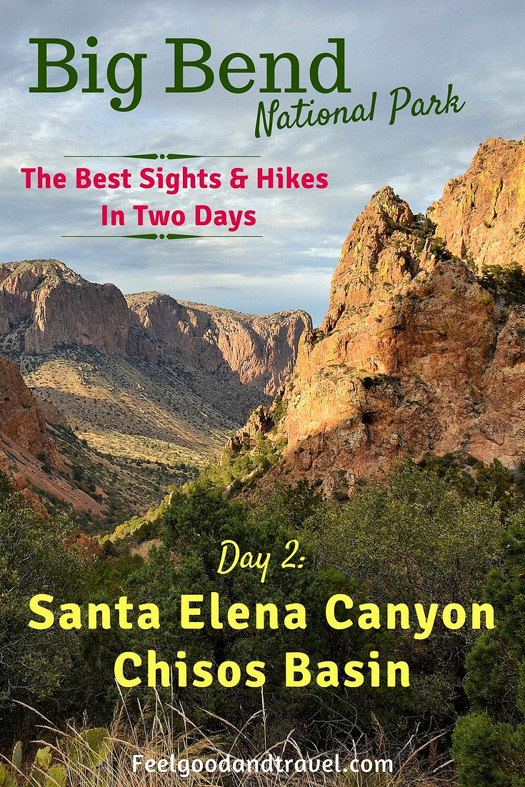
Santa Elena Canyon and Chisos Mountain Basin
Our second day in Big Bend started with a breakfast near the Study Butte/Terlingua Junction located two miles from the west entrance of the park. We tried to eat quickly, since we had a lot planned for the day. Getting the kids to move, and focus on our plan was another story. All they wanted to do was run around, and chase each other while howling like wild animals. Once we sort of got the situation under control, we made our way to Big Bend, entering at the Maverick Junction on the west side of the park.

Even before breakfast, the kids have plenty of energy
Head for Santa Elena Canyon
Our first major stop was going to be one of Big Bend’s most iconic and recognized points of interest: Santa Elena Canyon. As I looked at the map to verify how to get there, I noticed there were two ways. Right away, a brilliant idea dawned on me, we take one of the roads to the canyon, and the other one on the way back. This will allow us to see even more of the park, which is exactly what I am all about. Our main drivers, my hubby and my dad, didn’t seem to have to many objections.
Don’t Take Old Maverick Road Unless…
Conveniently, one of the roads leading to Santa Elena Canyon began right at Maverick Junction near the entrance to the park. It was the Old Maverick Road, and according to the map, it was unpaved. OK, not a big deal, I thought! So, we will bounce a little! We made a right turn, followed by my parents in their Toyota Prius, and very quickly realized that this would be more than just a bouncy ride. The road was very rough, and covered in potholes and bumps. After a minute or two of going very slowly, and getting tossed around in the car like lottery balls, the adults in our group decided to spare themselves the hassle, and turn back around. Honestly, I didn’t want to give it up and miss all the views from Old Maverick Road, but I had to follow the pack. I should be responsible and mention here that unless you have a Jeep or something equivalent, you may want to skip the Old Maverick Road, and go for pavement instead.
Take Ross Maxwell Scenic Drive Instead
After we slowly bounced our way back to the main road, we continued driving until we reached the Castolon/Santa Elena Junction. There, we made a right turn onto Ross Maxwell Scenic Drive, which offered a much smoother and more civilized ride. After cruising effortlessly for a few minutes, we were greeted by the jagged and massive silhouettes of the Chisos Mountains.
Skip the Ranch Remains
Further along the way, we passed a couple of former ranches, Sam Nail Ranch and Homer Wilson Ranch. These were remnants of a previous time when Big Bend was not yet a national park. People settled here to cultivate the land, and get a home with a view.

The view from the road near Sam Nail Ranch in Big Bend
We pulled over to take a few photos near Sam Nail Ranch, but did not actually hike to it. Time was ticking, and we had more exciting things to see. I would say, unless you have a special interest in old ranch remains, skip these, and get to the more interesting attractions up ahead.
Stop at Sotol Vista
Our first actual stop along Ross Maxwell Scenic Drive was at Sotol Vista.

View from Sotol Vista, Santa Elena Canyon can be seen off to the right far in the distance
Named after all the sotol plants that grow nearby, this overlook offered stunning views of Mexico and the nearby mountains, as well as Santa Elena Canyon. From this distance, the canyon appeared more like a crack, rather than an imposing gorge. It was not possible to comprehend its actual dimensions. The sign at Sotol Vista read:
Fourteen air-miles away, Santa Elena Canyon appears to be a small gap in the mesa. Its giant scale is not yet apparent. At the end of the Drive, a short trail enters the mouth of the gorge, where limestone walls tower 1,500 feet above the river.
This sounded pretty awesome, and I for one, couldn’t wait to “enter the mouth” of Santa Elena Canyon. I had seen so many pictures of it, and we were finally here in Big Bend, totally ready to get swallowed!

At Sotol Vista, I zoomed as much as I could on Santa Elena Canyon

Ross Maxwell Scenic Drive seen from Sotol Vista
Check out Mule Ears View Point
We continued our journey along Ross Maxwell Scenic Drive, and before long, arrived at another interesting spot, Mule Ears View Point. From here, we could see the two pointy cliffs that truly resembled…well…a mule’s ears. We stopped for a few minutes to enjoy the view and take pictures. The kids jumped in trying to pose with the ears above their heads making noises they believed in their minds were mule sounds. Before much longer, we had to put those two mules back in the car, and keep on driving.

Mule Ears in Big Bend National Park
If you are lucky to have more time, you can actually hike to the two rocky peaks; just follow Mule Ears Trail, which starts right from the parking area.

Continuing our drive on Ross Maxwell Scenic Drive
Pull Over at Tuff Canyon Overlook
Another interesting stop we made along Ross Maxwell Scenic Drive was at Tuff Canyon Overlook. I really had to push for this one, since the men in our group just wanted to keep driving. They did give in, though, and here we were, at this small canyon that had formed by runoff water during periods of flooding. It was surprisingly deep considering there was no river to carve it.

At Tuff Canyon Overlook near Ross Maxwell Scenic Drive. You can see the opening to the canyon off to the right.
The nearby sign explained that it was “much deeper than other dry washes at Big Bend”, and directed us to an easy 3/4-mile round trip trail leading to the bottom of Tuff Canyon. I was ready to start hiking, but was restrained by the adults in our group, who remember to look at the time a little more than I do. So, after a few more minutes of looking around, we returned back to the road, and sadly, I did not get to really experience Tuff Canyon. By all means, if you are not in a rush, take the short trail to the bottom, and do send me a few pictures from there!
Must Stop at Santa Elena Canyon Overlook
After passing Cottonwood and Castolon Visitor Center, we saw a sign that pointed towards the Santa Elena river access area. This is where you would come to start an epic rafting or kayaking journey on the Rio Grande, floating through the canyon. Unfortunately, we had not worked this into our plans, so we continued a little further, and stopped at Santa Elena Canyon Overlook instead. Here, for the first time, we began to comprehend the unbelievable magnitude of this gorge.

Santa Elena Canyon as seen from Santa Elena Canyon Overlook
We stood at the view point in complete awe for a few minutes while staring across the Rio Grande river where an enormous gap split the wall of giant cliffs. It was truly a monumental sight, enhanced by the fall colors of the trees near the bank of the river, and the joyous, really loud yelling of our kids! Be sure not to miss this stunning panorama, and definitely plan to stop here! It is a must for anyone visiting Big Bend National Park!
After gazing at this scenery a while longer, we continued driving towards the final point on the road, the Santa Elena Canyon Trail.
Hike Between the Walls of Santa Elena Canyon
We arrived at the end of Ross Maxwell Scenic Drive, got our backpacks on, and started walking on the trail. Now, we were really on a roll, headed directly for the mouth of the gorge!

Santa Elena Canyon, now much closer is about to swallow us all
The Hike
Trail: MODERATE unpaved path, climbing along switchbacks, 1.7 miles round trip
The path started nice and easy, leading us to an open space and across a shallow area of water that had run off from the Rio Grande. The kids found that quite amusing, and decided it would be a fun thing to just splash in it, rather than carefully step on the path of dry stones. It quickly dawned on them that their shoes were not totally waterproof, and by their reaction I concluded they didn’t quite enjoy wet socks and hiking boots. Oh, well! We had a canyon to see, and we were going with wet or dry feet!

On Santa Elena Canyon Trail after crossing some water, run off from the Rio Grande
From here on, the trail continued through a short stretch covered with trees, before reaching a series of switchbacks leading into the canyon. It is the ascent up the switchbacks that is the most strenuous part of the hike, but the good news is that it didn’t take that long. It also offered stunning views which helped us almost forget how out of shape our legs were.

The trail going through some low trees before leading to the switchbacks

Climbing up the switchbacks on Santa Elena Canyon Trail

Hubby with Angie and Dani posing with the view from the switchbacks on Santa Elana Canyon Trail

My dad, Dani, my hubby, and Angie resting after climbing the switchback section of the trail

Here I am, posing with the view of Santa Elena Canyon after finishing the climb on the switchbacks
We slowly made our way up the switchbacks, enjoying the scenery and taking plenty of photos. It was really good to discover that after the climb, the trail started to descend gently, taking us into the cool shade between the vertical walls of the canyon.

Looking at the Rio Grande into the canyon

A view of the Rio Grande from within the Santa Elena Canyon
Not Just a River, but “Liquid Sandpaper”
We continued to follow the path along the Rio Grande, while enjoying the amazing views from within the gorge. Everything was quiet and serene, except for our kids who were again yelping and chasing around, unable to follow the straight path. The river here was very calm, too, and it was hard to believe that it had somehow cut its way through these massive rocks. A sign we saw earlier at the overlook read:
Except during flood season, the quiet waters below do not seem powerful enough to have carved Santa Elena Canyon. Hike the short trail to the river and look closely at the water, cloudy with sand and silt. Like liquid sandpaper, the swift current files away at Santa Elena’s hard limestone, cutting it deeper. In a raft or canoe you can actually hear the grit hissing along the hull.
We walked a little further until we reached a giant rock, which marked the end of the trail.

The Rio Grande flowing calmly through Santa Elena Canyon

My dad standing in front of the giant rock at the end of Santa Elena Canyon Trail
After spending a short while there admiring the stunning scenery, we started walking back towards the parking area. There were still other places to explore, and more Big Bend adventures awaiting!

My mom walking back down on Santa Elena Canyon Trail
Take Ross Maxwell Scenic Drive Back
Once back to the cars, we all had a quick lunch of sandwiches and fruit, and started driving back on the Ross Maxwell Scenic Drive. We made only a couple of short stops along the way. One was at Castolon Visitor Center, where the kids presented their completed junior ranger booklets, and received the Big Bend Junior Ranger badges. After all, those badges are the greatest motivation for them to keep paying attention, and keep learning about the nature around them.
Check Out the Rocks at Burro Mesa Pouroff
The other stop we made on the way back was at a place called Burro Mesa Pouroff. Once again, I had to put on my puppy eyes, in order to get hubby to pull over. To get there, we turned left onto a short paved road that lead to a parking area. This is where a lengthy trail began towards Upper Burro Mesa. We didn’t have the time to hike it, so we enjoyed the views from the parking area. There were massive, reddish cliffs not too far off that rose high above the desert landscape.

View from Burro Mesa Pouroff parking area
It definitely looked like an interesting trail to hike, so next time we are back in Big Bend, I will plan to get us all to hike it!
Drive to Chisos Basin
We returned back to Ross Maxwell Scenic Drive for a while longer, then continued east on the main road. At Chisos Mountains Basin Junction, we turned right, and headed towards another section of the park that we had not yet explored: the Chisos Basin. This is where you will find Chisos Basin Visitor Center, and Chisos Mountains Lodge, the park’s only lodging accommodations other than camping.

On the road to Chisos Basin
Hike the Lost Mine Trail if You Can Find Parking, Or…
In Chisos Basin, there are also a number of excellent trails that lead high up in the mountains, offering breathtaking panoramas of the area. We were planning on hiking the Lost Mine Trail here, which is among the park’s most popular hikes. In fact, it is so popular that often there are no parking spots left in the tiny parking area at the trailhead, located on the side of the road. This is precisely what we discovered when we pulled over near the start of the trail. My head was immediately spinning with ideas about where we could leave the car, but hubby just did not want to create a parking space where there was none. Go figure! So, we decided to continue further down the road, and stop for a little bit at the Chisos Basin Visitor Center.

View of Chisos Basin from the road
Stop at the Chisos Basin Visitor Center
The whole area near the visitor center was truly beautiful, surrounded by the imposing rocks of the Chisos Mountains! After spending a little time there, and getting some small refreshments, we started driving back towards the Lost Mine Trailhead, hoping this time there would be a place to park.

More views of Chisos Basin from the road
Hike Lost Mine Trail if You Couldn’t Do It Earlier
Luckily, when we got there, we found that several cars had left, so we were all set, and ready to go. The only problem we had now was time. It was already around 4:30 pm, and considering that it was December, we didn’t have much daylight left. Regardless, we put on our backpacks, and started the hike up the Lost Mine Trail.
The Hike
Trail: MODERATE unpaved path, the trail ascends quite steeply at times, 4.8 miles round trip
The narrow path started ascending almost from the very beginning, leading us through a forest of low trees. Along the way, we found Yucca, Sotol, as well as Agave plants, some of them with long, black stems that had bloomed and died.

The stem of a Havard Agave. These plants bloom only once in their lifetime, then die

Havard Agave plant, which has not yet grown a stem

Sotol Plant on Lost Mine Trail in Big Bend

Interesting trees along Lost Mine Trail
As we climbed higher, we could see more of the Chisos Basin beneath, and large, steep rocks all around. The trail kept weaving in and out of the forest, passing near drop-offs, and uncovering more spectacular views. By this time, I had completely forgotten about the time, and totally focused on enjoying the hike, and taking photos.

View of the Chisos Mountains from Lost Mine Trail

Here I am, hiking a little higher on Lost Mine Trail
We were a little over half way, when hubby pointed out that the sun was getting pretty low. If we kept on going, we would have to hike back down in the dark. So, everyone in our group seemed to think it would be best to not go any further, and turn around. Let’s just say, I was not at all happy about this, but somewhere deep, deep in my mind, I knew it was the right call.

Looking at Juniper Canyon from Lost Mine Trail, on the way down

On Lost Mine Trail, getting lower to the parking area, as the sun is getting lower, too
Most definitely, if you have the time and enough daylight, go all the way to the top, and enjoy the amazing views along the way. There is a good reason why this hike is one of the most popular in the entire park! If you still need more convincing, HERE is a great article that will give you more information about the Lost Mine Trail.
Head Out West
Right around dusk, we arrived back down at the parking area, and started driving towards the west end of the park. There was hardly any light in the sky by this time. I felt great satisfaction mixed with a little bit of disappointment for not being able to wander around more. This is, however, very typical of me! I always underestimate the size of a place, and how long it would take to really explore it.
Dinner at High Sierra Bar & Grill
As we exited the park at Maverick Junction, I started checking my phone for a signal. It was that time again, when we had to decide where to get dinner. When I finally picked up some reception, I searched the local restaurants near the town of Terlingua, TX. I thought it was a ghost town, but apparently a ghost town with a few dining options. I discovered a place called High Sierra Bar & Grill, which sounded good from the reviews, so we decided to eat there.
It was a pleasant, two-story restaurant that served a lot of Mexican specialties. We placed our order, and after a somewhat lengthy wait enjoyed some tasty food.
As our two days in Big Bend came to an end, we headed back to our lodging for the night. Tired from all the excitement, everyone went to sleep quickly and soundly, except for me. My head was already spinning with plans and ideas about the things we needed to see and do at our next stop, Carlsbad Caverns National Park in New Mexico.
Additional Resources to Help Plan Your Big Bend Adventure
- Big Bend National Park – This is the official site created by the National Park Service. Here, you will find the latest information about the park, maps, active alerts, and more
- National Park Reservations: Big Bend National Park – On this website, you can find a variety of lodging options inside and near Big Bend National Park
- Visit Big Bend – Another website specifically dedicated to Big Bend National Park and the surrounding area.
- Big Bend National Park MAP – Here, you will get a PDF copy of the latest Big Bend National Park Map. It is identical to the one you will receive at the entrance
- Big Bend River Tours – Check out this website for information about river tours on the Rio Grande, an amazing way to experience the park
Big Bend Hikes: Information & Specifications
- Desert Hikes in Big Bend – A webpage created by the National Park Service that provides information about all the hikes you can take in the Big Bend desert regions.
- Mountain Hikes in Big Bend – Another webpage by the National Park Service that lists all the hikes you can take in the Big Bend mountain regions.
- River Hikes in Big Bend – Another page by the National Park Service, where you will find specific information about the Big Bend river hikes discussed in this post, and a few others.
Note: Unless otherwise indicated, all photos in this post were taken by me (Vessy) with my Nikon D3100 camera, and iPhone 6. All images are subject to copyright. Please contact us if you would like to use any of them!
This trip took place on December 28, 2016.
PIN THIS POST! 🙂
Big Bend Day 2 Pin
44 comments
That canyon is STUNNING! and the clouds in the sky — so so pretty! Great photos 🙂 I love how you have various members of your family all out hiking together.
Thank you so much! Yes, a lot of us are into hiking, and spending time in the great outdoors! 🙂
It’s beautiful there! Looks like a ton of fun and peaceful as well. Thanks for sharing!
These are such beautiful pictures! I felt like I was really there! Thank you for sharing!
I am so happy you stopped by, and I really appreciate your nice comment! I always try to capture as best as I can the experience, both with pictures and words! 🙂
A travel article that not only shows the sights, but gives honest advice? Rare – and beautifully done. Haven’t been to Big Bend yet, but I’m saving your post to review if we ever get there!
Awww, thank you so much for stopping by! I really appreciate your comment! It is a surprisingly beautiful place, and totally worth visiting! 🙂
Visiting the National Parks was one of my favorite things to do as a kid. I need to start visiting them again!
Our kids love it, too! It is truly an adventure! You never know what you will discover! 🙂
Love the path through the low tree branches, and the photography, and the descriptions.
Thank you so much! Yessss! I loved those fall colors! Not something we see often in Texas! 🙂
Some great tips, thank you for sharing. Enjoyed your pictures.
Thanks so much for stopping by, and leaving me such a nice comment! 🙂
Beautiful pictures. I don’t know if I will ever get to visit the National Parks. Thank you for the tour. Loved the “mouth” to the canyon pic and the walls. Fun trip!
Thank you so much! I sure hope you DO get to visit some of these American treasures! 😊
That looks like a great trip. Beautiful pictures.
Thanks so much for checking it out! It was a really nice and relaxing trip…:) 🙂 🙂
This is so pretty! Looks like an amazing trip! 🙂
We really had a good time in the Wild West of Texas! 🙂 🙂 🙂
AMAZING first picture at the top of your post. Truly amazing! Can’t wait to visit when we get going on our RVing journey. I pinned your post so that I could reference back to it. 🙂 Thanks for sharing!
Awww, thanks so much! How fun to go RVing around this wonderful country! Have fun, and keep me posted on all your adventures! 🙂
The pictures are amazing! I love the desert, but live no where near it! I grew up in Arizona though so this was a little reminder of “back home”
Oh, I LOVE Arizona…and YES, the desert definitely has its unique charm! Thanks so much for stopping by! 🙂
Wow! Quite a hike. I’d need to prepare for a trip like this. Thanks for your honesty of what is worth visiting and what isn’t. This is a trip for when the kids are just a little older and I don’t have to strap them to my back lol
It is definitely fun to go there with the kiddos…and there are plenty of easy hikes! We love visiting US National Parks as a family! 🙂
I spend so much time traveling outside the country, I sometimes forget the beauty right here in the US. We have been thinking about a move to Texas for some time now and this is a great article to run across. Thanks for sharing.
Thank you so much for stopping by! You are absolutely right! There is so much beauty in the USA! The National Parks alone are such an enormous treasure! Texas is definitely a nice place to live…well, I guess depends where you live…but there is a lot to see and enjoy for sure! 🙂
Wow! Amazing trip! The entire experience was exciting for me to read. I am definitely putting this at the top of my bucket list!
I am so happy to hear it! It is a beautiful, peaceful place… 🙂
I think my favorite picture is of the green trees on one of the trails. The leaves were so bright. All the other pictures were great as well. Looks like a fun place to visit!
Thanks so much! 🙂 It is a wonderful place to visit for sure! 🙂
You folks must be from California, to think you could go in the wildest area in a Prius. You know what high clearance & 4 wheel drive means? There are times after a rain you can’t get a real military hummer through. I used to have to rescue people when I was a peace officer because they would not use common sense. I am glad you turned around and had a good time, and came out safe. God Bless you folks, maybe the next time you come I can take you and show you some beautiful places there.
Well, thank you sir! It is so funny you think we are from California because of the Prius…we SURE DO LOVE California, and have been there many, many times, but we actually live in Texas at the moment! …Oh, and by the way, there are plenty of rough, dirt roads in California as well. 🙂 🙂 🙂
We LOVE California, we LOVE Texas, we LOVE the USA…and we love a Prius, too! It saves money, and it doesn’t pollute the environment as much, which is super important to us! Tell us about the beautiful places you had in mind to show us! I am very interested!!! 🙂 🙂 🙂
What an amazing hike and such beautiful pictures. I really had no idea there was such beauty there. Thanks for sharing!
I have nominated you for the Sunshine Blogger Award!
Lovingthejourney.net
Thank you so much! I truly appreciate it! 😊❤️😊
You took amazing photos! This looks amazing!
Thank you so much for stopping by! 😊
Good Morning, I admire you and your blog so have nominated you for the 2018 Liebster Award. Details will be in my blog post this week.
Thank you so much Verla! I am very honored, but I was already nominated, and if you scroll down you can see my post! 😊
I really appreciate it! ❤️
Vessy-nice job bringing visibility to this beautiful park. We loved the Lost Mine Trail as well. We did that when we first entered the park and were blown away! This is not what we expected in Texas!
Thanks so much Pete! It really is a beautiful hike, and a great park! I live on the other side of Texas, and never expected the West had so much to offer! 🙂
As a native Texan who has experienced BBNP several times camping in the Chisos Mountains, you could have planned your 2-day visit even better regarding trail length/difficulty and other details that would have avoided changes in plans, curtailing hiking and other minor disappointments. Please do return to BBNP and try to spend at least 3 or 4 days…or more there.
Thanks Patrick! We would definitely LOVE to come back to Big Bend, and YES…next time we will be better prepared. The truth is, I had it all mapped out and planned out, but when you travel with a group of people including kids, things don’t always work out as planned! 🙂